
LF Zuiderzeeroute
Plan, record and navigate on the go
All routes and points of interest in your pocket — with the free VeloPlanner app.


The LF Zuiderzee Route is a loop that starts and finishes in Amsterdam and circles the IJsselmeer and Markermeer, the lakes that were once the Zuiderzee. That sea was only brought under control in the 20th century, when the Afsluitdijk closed it off from the Wadden Sea.
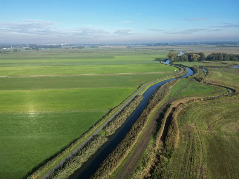
The route is a ride through the Dutch fight with water. You cross large areas of reclaimed land and pass pumping stations, dikes and barrages. In between come medieval trading towns such as Hoorn, Enkhuizen and Kampen, the former island of Schokland, and a string of fishing villages and harbours where the Zuiderzee fleet used to sail from.
LF Zuiderzee Route key facts
- Start and finish: Amsterdam (loop route)
- Typical duration: 8 days following the eight official daily stages
- Terrain: flat polder and dike landscape for long stretches; gently rolling in the Gaasterland area of Friesland
- Water crossings: a bicycle ferry at Horst beach on the route itself, plus an optional seasonal ferry between Enkhuizen and Stavoren
- World Heritage on the route: Schokland, the Ir. D.F. Woudagemaal and views over the Wadden Sea from the Afsluitdijk
- Navigation: GPX track available directly in VeloPlanner
Which direction to ride the LF Zuiderzee Route and when to go
The official daily stages run from Amsterdam north through Waterland to Hoorn and Medemblik, cross the Afsluitdijk into Friesland, then head south through Lemmer, the Noordoostpolder and Kampen before following the lakes along the edge of Flevoland back towards Amsterdam. Following that order keeps your trip in line with the official stage descriptions.
If you want the shortcut ferry between Enkhuizen and Stavoren, plan your trip between April and October, when it sails.
The eight daily stages of the LF Zuiderzee Route
The route operator divides the loop into eight daily stages, each starting and ending in a town with a Zuiderzee past.
Amsterdam – Hoorn
Within minutes of the city you cross the Schellingwoude Bridge, pass under the ring road and reach the polders of Waterland, with a first view over the water near Durgerdam. Monnickendam and Edam, both busy trading towns in the 16th and 17th centuries, still have streets lined with merchant houses and warehouses, and Volendam began around 1600 as a suburb of Edam. Past Warder and Schardam you ride by two pumping stations that keep North Holland, which lies mostly below sea level, dry.
Hoorn – Medemblik
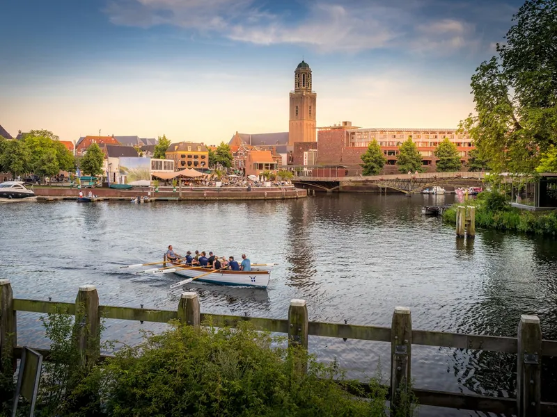
Hoorn was briefly Holland's leading trading city early in the Eighty Years' War, and the friezes on the Bossuhuizen at Slapershaven 1 show the Battle of the Zuiderzee fought off the town. Enkhuizen, like Hoorn, was a base for the Dutch East India Company (VOC) in the Golden Age, and its Zuiderzee Museum tells that story in detail.
Medemblik – Workum
Between Medemblik and Den Oever you cross the Wieringermeerpolder, the only true Zuiderzee polder, drained in 1930 before the Afsluitdijk existed. Near Den Oever the Dijkgatbos marks the spot where German troops blew two holes in the polder dike in 1945. Then comes the dead-straight ride along the Afsluitdijk into Friesland, with the Wadden Sea on your left and the freshwater IJsselmeer on your right, followed by Makkum and its 17th-century mansions, weigh house and warehouses.
Workum – Lemmer
From Workum, a port town since around 1400, the route follows the Aldedyk, an old Zuiderzee dike, to Hindeloopen and on via Molkwerum to Stavoren, the oldest city in Friesland. The Gaasterland that follows is the hilliest part of the loop: forests, bays and low cliffs formed by glaciers during the Ice Age. A short detour near the Sylroede takes you to the Ir. D.F. Woudagemaal.
Lemmer – Kraggenburg
Lemmer, once one of the country's main fishing towns, is now a water sports centre. From here the route turns inland but keeps to dikes for long stretches, passing the former sea ports of Kuinre and Blokzijl. Near Vollenhove the water comes back into view, and the Vollenhover Canal marks the border between Overijssel and Flevoland.
Kraggenburg – Elburg
This stage crosses the Noordoostpolder via Kraggenburg and the Voorsterbos, through land laid out in straight lines. Schokland, an island until the land was reclaimed, rises out of the polder with its dried-up harbour and museum. Over the Ramspol barrage you return to old land and ride through the Hanseatic city of Kampen before following the Veluwemeer.
Elburg – Spakenburg
Elburg's street plan and buildings date back to its walls of 1392. The route follows the lakes along the edge of the Flevopolder to Harderwijk, a Hanseatic town where Zuiderzee fishing mattered until 1932, then crosses the water by bicycle ferry at Horst beach into Southern Flevoland. After Zeewolde you ride a long stretch through the Horsterwold.
Spakenburg – Amsterdam
Spakenburg's old harbour holds around thirty botters, the 19th-century Zuiderzee fishing boats. After open grassland and the city beach of Huizen, the route follows the Gooimeer to the fortified town of Naarden, inside the Amsterdam Defence Line. Past the Muiderslot and through Muiden, a bike path takes you back into Amsterdam to close the loop.
What to see along the LF Zuiderzee Route
Most highlights fall into three groups: water engineering, historic Zuiderzee towns, and the few forests and nature areas on an otherwise open route.
Water engineering and World Heritage
- Afsluitdijk: the dike that closed off the Zuiderzee, with the Wadden Sea (a UNESCO World Heritage Site and the largest tidal area in the world) on one side
- Ir. D.F. Woudagemaal: Amsterdam School pumping station, UNESCO-listed since 1998 and the largest steam pumping station in the world still in operation
- Schokland: former island, now a UNESCO World Heritage Site; its last 600 inhabitants were evacuated in 1859, and Museum Schokland displays a prehistoric footprint found during the drainage
- Cees Mantel Pumping Station: opened in 2017, it moves 2,000 cubic metres of water per minute, about an Olympic swimming pool
- Warder Pumping Station: built in 1998, with a clear view of how much higher the Markermeer sits than the polder behind it
- Westfriese Omringdijk: a 126-kilometre sea dike formed in the 13th century when the West Frisians joined their smaller dikes
- Wieringermeerpolder: drained in 1930, the only polder reclaimed before the Afsluitdijk was built
- Ramspol barrage: the crossing from the Noordoostpolder back to the old land
Historic towns and harbours
- Hoorn and Enkhuizen: Golden Age VOC cities; the Zuiderzee Museum in Enkhuizen covers the region's history
- Monnickendam, Edam and Volendam: former trading towns with merchant houses and warehouses
- Makkum: once called the "Gateway to the Zuiderzee", with 17th-century mansions and a weigh house
- Workum, Hindeloopen and Stavoren: three of the Frisian Eleven Cities; Stavoren is the oldest city in Friesland
- Kuinre old harbour: now in the middle of the Kuinderbos, 200 metres off the route, marked by a mushroom-shaped signpost
- Kampen: late-medieval Hanseatic city with city gates, parts of the old Town Hall, the Gothic House and the City Bridge
- Elburg: square fortified town inside walls from 1392, with its church on the edge of town
- Spakenburg: about half of the Dutch botter fleet moored in the old harbour
- Naarden, Muiden and the Muiderslot: fortified towns of the Amsterdam Defence Line
Nature and landscape
- Waterland: peatland of ditches and small lakes just north of Amsterdam
- Gaasterland: forests, bays and cliffs on Ice Age ridges known as "gaasten", with views over the IJsselmeer past the turnoff to Skarl
- Horsterwold: the largest continuous deciduous forest in the Netherlands, young but with sizeable trees
- Dijkgatbos: forest near Den Oever planted after the 1945 dike breach
Practical considerations for the LF Zuiderzee Route
Most of the planning on this route revolves around water crossings. Check the current ferry schedules on veerponten.nl before you set off, as the route depends on them.
- Enkhuizen–Stavoren ferry: sails April–October, a crossing of under an hour and a half, operating since 1886. It shortcuts the loop, so you skip the Afsluitdijk and a large part of the route.
- Horst beach bicycle ferry: part of the Elburg–Spakenburg stage, crossing to Southern Flevoland.
- Afsluitdijk access: according to the route operator, the Afsluitdijk was not open to cyclists until the end of 2025, with a free bicycle bus running in the meantime. Check the current status before planning this stage.
Near the Ir. D.F. Woudagemaal the route runs for a stretch along a busier N-road on the Sylroede; the detour to the pumping station turns right just after the bridge. Traffic also picks up on the final stage as you approach Amsterdam.
Tips for planning your LF Zuiderzee Route trip
Decide early whether you will ride the Afsluitdijk or take the Enkhuizen–Stavoren ferry, since that choice shapes your whole itinerary and the ferry only runs in season. Leave time for detours that sit just off the line, such as Kuinre's old harbour and the Woudagemaal, and for the museums in Enkhuizen and on Schokland.
If eight days is more than you have, the route operator also offers a shorter LF weekend tour as a first taste. For the full loop, open the route in the VeloPlanner planner to split it into days that suit your pace.
Frequently Asked Questions
Where can I download the GPX for the LF Zuiderzee Route?
Can you cycle across the Afsluitdijk?
Can you take a ferry from Enkhuizen to Stavoren on the LF Zuiderzee Route?
How many days does the LF Zuiderzee Route take?
Where does the LF Zuiderzee Route start and end?
Plan, record and navigate on the go
All routes and points of interest in your pocket — with the free VeloPlanner app.



Comments
Log in to comment Ask a question or share a tip…No comments yet. Ask about closures, surfaces or places to stay, or share a tip from your ride.